![](/images/other/stat-length.png)
![Tour Wandern La Ferté-Gaucher - la ferte - st martin - Photo](https://media.geolcdn.com/t/1900/400/ext.pjpeg?maxdim=2&url=https%3A%2F%2Fstatic1.geolcdn.com%2Fsiteimages%2Fupload%2Ffiles%2F1553511878bg_sport_marche.png)
la ferte - st martin
alex77
Benutzer
![Länge](/images/other/stat-length.png)
Länge
7,8 km
![Maximale Höhe](https://static1.geolcdn.com/siteimages/upload/files/1508320355ic_sort_altitude_max_24dp.png)
Maximale Höhe
159 m
![Positive Höhendifferenz](https://static1.geolcdn.com/siteimages/upload/files/1508320355ic_sort_den_pos_24dp.png)
Positive Höhendifferenz
81 m
![Km-Effort](/images/other/stat-length.png)
Km-Effort
8,8 km
![Min. Höhe](https://static1.geolcdn.com/siteimages/upload/files/1508320355ic_sort_altitude_min_24dp.png)
Min. Höhe
110 m
![Negative Höhendifferenz](https://static1.geolcdn.com/siteimages/upload/files/1508320355ic_sort_den_neg_24dp.png)
Negative Höhendifferenz
82 m
![Boucle](https://static1.geolcdn.com/siteimages/upload/files/16400158638029165_repeat_loop_refresh_sync_direction_icon.png)
Boucle
Ja
Erstellungsdatum :
2014-12-10 00:00:00.0
Letzte Änderung :
2014-12-10 00:00:00.0
![Wandern](https://static1.geolcdn.com/sitytour/trail-icons/101.png)
1h59
Schwierigkeit : Sehr leicht
![Scannen Sie diesen QR-Code, um die Tour in der SityTrail-Anwendung zu öffnen](https://capi.geolives.com/qq0zvz2zws4bq2lad0pu/sitytour/trails/173804/qr.png?size=200)
Kostenlosegpshiking-Anwendung
Über SityTrail
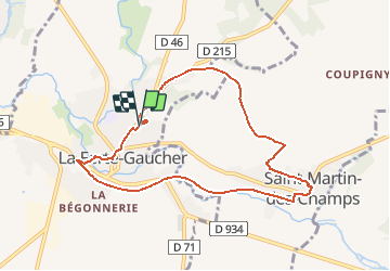
Tour Wandern von 7,8 km verfügbar auf Île-de-France, Seine-et-Marne, La Ferté-Gaucher. Diese Tour wird von alex77 vorgeschlagen.
Beschreibung
de la ferté gaucher à saint martin, en passant par la commanderie, la promenade est agréable, avec de jolis points de vue. le retour se fera par l'ancienne voie ferrée.
Ort
Land:
France
Region :
Île-de-France
Abteilung/Provinz :
Seine-et-Marne
Kommune :
La Ferté-Gaucher
Standort:
Unknown
Gehen Sie:(Dec)
Gehen Sie:(UTM)
522666 ; 5403569 (31U) N.
Kommentare
Touren in der Umgebung
![Tour Wandern La Ferté-Gaucher - la comanderie - Photo](https://media.geolcdn.com/t/375/260/ext.jpg?maxdim=2&url=https%3A%2F%2Fservices.sitytrail.com%2FGeolivesWS%2FDownloadMedia.ashx%3FTrailID%3D139844%26Media%3D20120718193702.jpeg)
![Wandern Wandern](https://static1.geolcdn.com/sitytour/trail-icons/101.png)
la comanderie
Wandern
Einfach
(1)
La Ferté-Gaucher,
Île-de-France,
Seine-et-Marne,
France
![](/images/other/stat-length.png)
5,8 km | 6,6 km-effort
1h 17min
![](https://static1.geolcdn.com/siteimages/upload/files/16400158638029165_repeat_loop_refresh_sync_direction_icon.png)
Ja
![Tour Wandern Jouy-sur-Morin - Randonnée à Jouy sur Morin - Photo](https://media.geolcdn.com/t/375/260/ext.jpg?maxdim=2&url=https%3A%2F%2Fstatic1.geolcdn.com%2Fsiteimages%2Fupload%2Ffiles%2F1553511878bg_sport_marche.png)
![Wandern Wandern](https://static1.geolcdn.com/sitytour/trail-icons/101.png)
Randonnée à Jouy sur Morin
Wandern
Schwierig
(1)
Jouy-sur-Morin,
Île-de-France,
Seine-et-Marne,
France
![](/images/other/stat-length.png)
14,5 km | 18,2 km-effort
3h 52min
![](https://static1.geolcdn.com/siteimages/upload/files/16400158638029165_repeat_loop_refresh_sync_direction_icon.png)
Ja
![Tour Pferd La Chapelle-Moutils - 2010-08-03 - 17h08m31 - Photo](https://media.geolcdn.com/t/375/260/ext.jpg?maxdim=2&url=https%3A%2F%2Fservices.sitytrail.com%2FGeolivesWS%2FDownloadMedia.ashx%3FTrailID%3D42903%26Media%3Dimage0.jpg)
![Pferd Pferd](https://static1.geolcdn.com/sitytour/trail-icons/300.png)
2010-08-03 - 17h08m31
Pferd
Sehr leicht
La Chapelle-Moutils,
Île-de-France,
Seine-et-Marne,
France
![](/images/other/stat-length.png)
7 km | 7,7 km-effort
Unbekannt
![](https://static1.geolcdn.com/siteimages/upload/files/16400158638029165_repeat_loop_refresh_sync_direction_icon.png)
Ja
![Tour Wandern Jouy-sur-Morin - Jouy sur Morin/Fontaine Janvier - Photo](https://media.geolcdn.com/t/375/260/ext.jpg?maxdim=2&url=https%3A%2F%2Fstatic1.geolcdn.com%2Fsiteimages%2Fupload%2Ffiles%2F1553511878bg_sport_marche.png)
![Wandern Wandern](https://static1.geolcdn.com/sitytour/trail-icons/101.png)
Jouy sur Morin/Fontaine Janvier
Wandern
Schwierig
Jouy-sur-Morin,
Île-de-France,
Seine-et-Marne,
France
![](/images/other/stat-length.png)
11,6 km | 13,3 km-effort
3h 1min
![](https://static1.geolcdn.com/siteimages/upload/files/16400158638029165_repeat_loop_refresh_sync_direction_icon.png)
Ja
![Tour Wandern Jouy-sur-Morin - Un Tour de Jouy - Photo](https://media.geolcdn.com/t/375/260/ext.jpg?maxdim=2&url=https%3A%2F%2Fstatic1.geolcdn.com%2Fsiteimages%2Fupload%2Ffiles%2F1553511878bg_sport_marche.png)
![Wandern Wandern](https://static1.geolcdn.com/sitytour/trail-icons/101.png)
Un Tour de Jouy
Wandern
Sehr leicht
Jouy-sur-Morin,
Île-de-France,
Seine-et-Marne,
France
![](/images/other/stat-length.png)
8,7 km | 10,3 km-effort
2h 4min
![](https://static1.geolcdn.com/siteimages/upload/files/16400158638029165_repeat_loop_refresh_sync_direction_icon.png)
Ja
![Tour Wandern Jouy-sur-Morin - Chemin des Cailles - Photo](https://media.geolcdn.com/t/375/260/ext.jpg?maxdim=2&url=https%3A%2F%2Fstatic1.geolcdn.com%2Fsiteimages%2Fupload%2Ffiles%2F1553511878bg_sport_marche.png)
![Wandern Wandern](https://static1.geolcdn.com/sitytour/trail-icons/101.png)
Chemin des Cailles
Wandern
Einfach
Jouy-sur-Morin,
Île-de-France,
Seine-et-Marne,
France
![](/images/other/stat-length.png)
9,2 km | 11,3 km-effort
2h 26min
![](https://static1.geolcdn.com/siteimages/upload/files/16400158638029165_repeat_loop_refresh_sync_direction_icon.png)
Ja
![Tour Mountainbike Choisy-en-Brie - vtt - Photo](https://media.geolcdn.com/t/375/260/ext.jpg?maxdim=2&url=https%3A%2F%2Fstatic1.geolcdn.com%2Fsiteimages%2Fupload%2Ffiles%2F1524743154velo.jpg)
![Mountainbike Mountainbike](https://static1.geolcdn.com/sitytour/trail-icons/202.png)
vtt
Mountainbike
Einfach
Choisy-en-Brie,
Île-de-France,
Seine-et-Marne,
France
![](/images/other/stat-length.png)
13,8 km | 14,9 km-effort
58min
![](https://static1.geolcdn.com/siteimages/upload/files/16400158638029165_repeat_loop_refresh_sync_direction_icon.png)
Ja
![Tour Fahrrad La Ferté-Gaucher - Balade en vélo rail - Photo](https://media.geolcdn.com/t/375/260/ext.jpg?maxdim=2&url=https%3A%2F%2Fstatic1.geolcdn.com%2Fsiteimages%2Fupload%2Ffiles%2F1524743154velo.jpg)
![Fahrrad Fahrrad](https://static1.geolcdn.com/sitytour/trail-icons/200.png)
Balade en vélo rail
Fahrrad
Sehr leicht
La Ferté-Gaucher,
Île-de-France,
Seine-et-Marne,
France
![](/images/other/stat-length.png)
9,8 km | 11 km-effort
Unbekannt
![](https://static1.geolcdn.com/siteimages/upload/files/16400158638029165_repeat_loop_refresh_sync_direction_icon.png)
Nein
![Tour Wandern Jouy-sur-Morin - Jouy sur Morin - Photo](https://media.geolcdn.com/t/375/260/ext.jpg?maxdim=2&url=https%3A%2F%2Fstatic1.geolcdn.com%2Fsiteimages%2Fupload%2Ffiles%2F1553511878bg_sport_marche.png)
![Wandern Wandern](https://static1.geolcdn.com/sitytour/trail-icons/101.png)
Jouy sur Morin
Wandern
Medium
Jouy-sur-Morin,
Île-de-France,
Seine-et-Marne,
France
![](/images/other/stat-length.png)
8,5 km | 10 km-effort
1h 59min
![](https://static1.geolcdn.com/siteimages/upload/files/16400158638029165_repeat_loop_refresh_sync_direction_icon.png)
Ja